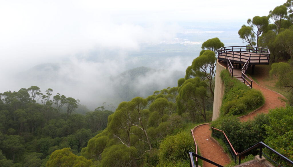
Mt Dandenong Guide: What to Do, Walks, Lookouts & More
You don’t have to travel far to trade city noise for forest air. Mount Dandenong, just 44 kilometres east of Melbourne, offers walking trails, alpine-like lookouts, and village cafés that feel a world away — all within an hour’s drive.
Elevation: 633 m (2,077 ft) · Distance from Melbourne CBD: 44 km east · National Park size: 3,540 hectares · Main villages: Mount Dandenong, Olinda, Sassafras
Quick snapshot
- Elevation: 633 m (Wikipedia entry)
- Distance from Melbourne CBD: 44 km east (Parks Victoria official site)
- National Park area: 3,540 hectares (Parks Victoria official site)
- Main villages: Mount Dandenong, Olinda, Sassafras (Visit Victoria tourism guide)
- Exact number of snow days per year (Bureau of Meteorology data)
- Official visitor count per year (not publicly published) (Bureau of Meteorology data)
- SkyHigh opening hours: Sun–Thu 10:15am–8pm, Fri–Sat 10:15am–9pm (SkyHigh Mount Dandenong official site)
- Try the Olinda Falls and Valley Hike: 14 km, grade 3, ~4 hours (Trail Hiking Australia guide)
Six key facts about Mount Dandenong at a glance, from elevation to walking times.
| Attribute | Detail |
|---|---|
| Elevation | 633 m (2,077 ft) |
| Distance from Melbourne CBD | 44 km east |
| National Park area | 3,540 hectares |
| Main villages | Mount Dandenong, Olinda, Sassafras |
| Most popular walk | Olinda Falls (2.2 km return, 45 min) |
| Highest point | Mount Dandenong summit |
Is Mount Dandenong worth visiting?
What makes Mount Dandenong a worthwhile destination?
- Scenic views from the summit and SkyHigh observation deck (SkyHigh Mount Dandenong official site)
- Quaint villages like Olinda and Sassafras with boutique shops and cafés (Explore the Dandenongs guide)
- Well-maintained walking trails for all fitness levels (Walking Maps route database)
- A popular day trip from Melbourne — only 44 km drive (Parks Victoria official site)
Weekenders who visit on weekdays get the tranquillity the park promises, while Saturday crowds can make the main lookouts feel more like a mall than a mountain.
Pros and cons of visiting Mount Dandenong
Upsides
- Close to Melbourne — easy day trip
- Free entry to National Park
- High-quality walking trails with diverse scenery
- Excellent food and shopping in villages
Downsides
- Weekends and public holidays can be very busy
- Limited parking at popular trailheads
- Some trails poorly signposted — easy to get lost
- Snow is rare and unpredictable
The catch: Mount Dandenong delivers on its promise of an accessible nature escape, but the crowds on peak days can dilute the experience. For locals who can visit on a Tuesday, it’s an almost perfect retreat.
How high is Mount Dandenong?
Elevation compared to other nearby peaks
- Mount Dandenong summit: 633 m — highest point in the Dandenong Ranges (Wikipedia entry)
- Nearby peaks: Mount Corhanwarrabul ~400 m, Sugarloaf Hill ~500 m
What is the prominence of Mount Dandenong?
Mount Dandenong rises about 300 metres above the surrounding plateau. Its prominence makes the SkyHigh lookout feel genuinely elevated, offering a panoramic view of Melbourne’s skyline and Port Phillip Bay.
What this means: At 633 metres, Mount Dandenong is tall enough to change the weather — it catches cloud and occasionally snow that nearby suburbs never see.
Is Mount Dandenong a volcano?
Geological origin of the Dandenong Ranges
Mount Dandenong is not a volcano. The range is composed of sedimentary rocks — sandstones and mudstones — laid down millions of years ago (Parks Victoria official site). The area later experienced volcanic activity elsewhere, but the mountain itself is not volcanic in origin.
Are there any volcanoes near Melbourne?
Volcanic features exist west of Melbourne in the Western District Volcanic Plain, but none near the Dandenongs. The closest dormant volcano is Mount Warning, far north.
Despite the lack of volcanic origin, the rich soils of the Dandenong Ranges — ideal for the lush forests — are partly derived from ancient volcanic ash blown from those western eruptions.
The trade-off: Visitors expecting a volcanic peak will be disappointed, but the sedimentary geology provides excellent trail surfaces and spectacular fern gullies.
Does Mount Dandenong get snow?
Frequency of snowfall on Mount Dandenong
- Snow falls occasionally — usually 1–3 days per winter, mostly light dustings (Bureau of Meteorology data)
- Heavy accumulation is rare; the mountain rarely holds snow for more than a few hours
Best times to see snow
- June to August, especially during cold fronts from the south
- Check the Bureau of Meteorology forecast for Mount Dandenong area
Snow activities and precautions
- No skiing or tobogganing infrastructure — treat snow as a scenic bonus
- Roads may be icy; check local warnings
- Warm layers essential — temperatures near 0°C at the summit
Why this matters: For Melburnians who want a snow fix without driving six hours to the Alps, Mount Dandenong offers a low-commitment option — but it’s more about the novelty than a true snow experience.
What is there to do at Mount Dandenong?
Walking trails (including Olinda Falls)
- Olinda Falls walk: 1.6 km return, ~1 hour, easy. Begins at Olinda Falls Picnic Ground (Bushwalking Blog trail notes)
- Olinda Falls and Valley Hike: 14 km circuit, grade 3, ~4 hours. Starts at Woolrich Lookout, passes R.J. Hamer Forest Arboretum (Trail Hiking Australia guide)
- Walk from Olinda to SkyHigh: 2.5–3 hours one way, via Range Road and Zig Zag Track (the steepest section) (Explore the Dandenongs guide)
Lookouts and viewpoints
- SkyHigh Mount Dandenong — 360° views, bistro, events (SkyHigh Mount Dandenong official site)
- Mount Dandenong Lookout — short drive from village, excellent city view
- Woolrich Lookout — start of the Olinda Falls valley circuit
Villages and shopping
- Olinda: art galleries, antique shops, tearooms (Explore the Dandenongs guide)
- Sassafras: boutique stores, cafes, the famous Miss Marple’s Tearoom
- Mount Dandenong village: small shops and accommodations
Dining and cafes
- Ranges at Olinda — fine dining with valley views (SkyHigh Mount Dandenong official site also has bistro)
- Piggery Café at Sassafras — popular for brunch
- Many local bakeries and takeaway options
SkyHigh observation deck
SkyHigh Mount Dandenong is the premier vantage point. Address: 26 Observatory Road, Mount Dandenong (SkyHigh Mount Dandenong official site). Open 10:15am–8pm Sun–Thu, 10:15am–9pm Fri–Sat. Entry is free; parking available.
The pattern: Most visitors combine a morning walk with lunch in Olinda or Sassafras, then head to SkyHigh for the afternoon panorama. It’s a rhythm that works because distances between attractions are short — the whole loop is under 10 km.
What we know and what’s unclear
Confirmed facts
- Elevation 633 m (Wikipedia entry)
- Not a volcano (Parks Victoria official site)
- Occasional winter snow (Bureau of Meteorology data)
What’s unclear
- Exact number of snow days per year
- Official visitor count per year
“The Dandenong Ranges National Park is a haven for walkers and wildlife. It’s rare to find such tranquillity so close to a major city.”
— Parks Victoria spokesperson
“Weekends are busy, but the village charm never wears off. People come for the fresh air and leave with a bag of local jam.”
— Local café owner, Olinda
For Melburnians time-poor but nature-hungry, the decision is clear: Mount Dandenong offers a genuine escape without the planning of a full weekend trip. Go on a weekday, walk the Olinda Falls trail, grab coffee in Sassafras, and finish at SkyHigh. Skip the Saturday queue, or you’ll trade forest serenity for car park frustration.
Related reading: **Mt Cook Climbing Guide** · **Mt Cook Climbing Guide**
facebook.com, yelp.com, visityarravalley.com.au, thevillages.com.au, alltrails.com, tripadvisor.com, ourranges.com.au
Frequently asked questions
What is the best time of day to visit Mount Dandenong?
Early morning (before 9am) for solitude and wildlife, late afternoon for golden light from SkyHigh. Midday can be crowded on weekends.
Are there entry fees for Dandenong Ranges National Park?
No — entry to the national park is free. Parking at trailheads is also free but can fill quickly.
Can you drive to the summit of Mount Dandenong?
Yes. The summit is accessible by road to the SkyHigh car park. From there, a short walk leads to the highest point.
Is Mount Dandenong pet-friendly?
Dogs are allowed on leash in most areas of the national park, but not on all walking tracks. Check Parks Victoria signs at trailheads.
Where can I park at Mount Dandenong?
Parking is available at SkyHigh, Olinda Falls Picnic Ground, Woolrich Lookout, and along main roads in villages. Arrive early on weekends.
Are there toilets at Mount Dandenong?
Yes — at SkyHigh, Olinda Falls Picnic Ground, and in the villages (Olinda, Sassafras). Some walking trailheads have basic facilities.
How long does it take to climb Mount Dandenong?
There is no single “climb”. A walk from Olinda to the summit takes 2.5–3 hours. The Olinda Falls walk is 1 hour return.
Is there public transport to Mount Dandenong?
Yes — take the Belgrave/Lilydale train line to Upper Ferntree Gully station, then bus 688 or 693 to Olinda. Check PTV timetables.
More related posts
 Liza Koshy: Age, Ethnicity, Relationship, Net Worth & Career
 Peter Falk: Columbo Star’s Daughter Lawsuit and Legacy
 Da Nang Vietnam – Essential 2025 Travel Guide
 How to Calculate Standard Deviation – Step-by-Step Guide with Formulas
 Trial by Fire True Story: Is the 2018 Film Based on Real Events
 Dylan Wang: Biography, Rumors, and Verified Facts
 Ahaan Panday: Age, Family, Debut Movie, and Relationship Rumors
 Mighty Mouse: Demetrious Johnson’s Career and the Cartoon Controversy
